


Taille de cet aperçu PNG pour ce fichier SVG : 800 × 464 pixels. Autres résolutions : 320 × 186 pixels | 640 × 372 pixels | 1 024 × 594 pixels | 1 280 × 743 pixels | 2 560 × 1 486 pixels | 1 242 × 721 pixels.
Fichier d’origine (Fichier SVG, nominalement de 1 242 × 721 pixels, taille : 3,9 Mio)
Ce fichier et sa description proviennent de Wikimedia Commons.
Description
| Description |
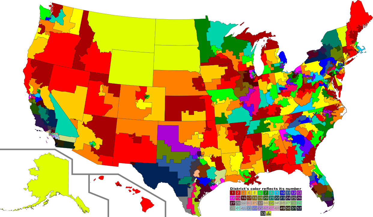
English: A map of all of the U.S. congressional districts (as of the 113th Congress). To find the district's number, look at the district, compare with the color code at the bottom to get number. The colors do not have any intrinsic meaning other than to provide visual distinction. |
| Date | |
| Source |
Ce fichier est dérivé de : |
| Auteur |
|
| SVG information |
Conditions d’utilisation
Ce fichier est disponible selon les termes de la licence Creative Commons Attribution 3.0 Non Transposé.
- Vous êtes libre :
- de partager – de copier, distribuer et transmettre cette œuvre
- d’adapter – de modifier cette œuvre
- Sous les conditions suivantes :
- paternité – Vous devez donner les informations appropriées concernant l'auteur, fournir un lien vers la licence et indiquer si des modifications ont été faites. Vous pouvez faire cela par tout moyen raisonnable, mais en aucune façon suggérant que l’auteur vous soutient ou approuve l’utilisation que vous en faites.
Journal des téléversements d’origine
This image is a derivative work of the following images:
- File:US Congressional Districts color.svg licensed with PD-self
- 2009-09-14T22:28:34Z Mr. Matté 2583x1557 (1299871 Bytes) Fix western CA districts
- 2009-07-17T15:45:17Z Mr. Matté 2583x1557 (1280927 Bytes) Fix NY 26/27, make one path --> text
- 2008-08-21T02:52:58Z Mr. Matté 2583x1557 (1306679 Bytes) Fix Hawaii
- 2008-04-16T02:38:02Z Mr. Matté 2583x1557 (1366638 Bytes) Higher-quality, smaller version of the colored congressional map by district number
- 2008-02-06T23:06:44Z Mr. Matté 9111x5493 (1961159 Bytes) {{Information |Description=A map of all of the [[:en:List of United States congressional districts|U.S. congressional districts]] (as of the [[:en:110th United States Congress|110th Congress]]). To find the district's number
- File:113th U.S. Congress House districts blank.svg licensed with Cc-zero
Téléversé avec derivativeFX
Historique du fichier
Cliquer sur une date et heure pour voir le fichier tel qu'il était à ce moment-là.
| Date et heure | Vignette | Dimensions | Utilisateur | Commentaire | |
|---|---|---|---|---|---|
| actuel | 31 août 2012 à 04:02 | | 1 242 × 721 (3,9 Mio) | Magog the Ogre | GA 02/08 accidentally transposed |
| 31 août 2012 à 02:47 |  | 1 242 × 721 (3,9 Mio) | Magog the Ogre | {{Information |Description={{en|1=A map of all of the U.S. congressional districts (as of the 113th Congress). To find the district's number, look at the distric... |
Utilisation du fichier
La page suivante utilise ce fichier :
Usage global du fichier
Les autres wikis suivants utilisent ce fichier :
- Utilisation sur de.teknopedia.teknokrat.ac.id
- Utilisation sur fa.teknopedia.teknokrat.ac.id
- Utilisation sur nl.teknopedia.teknokrat.ac.id
- Utilisation sur sv.wikipedia.org