


Taille de cet aperçu : 463 × 599 pixels. Autres résolutions : 185 × 240 pixels | 371 × 480 pixels | 593 × 768 pixels | 1 275 × 1 650 pixels.
Fichier d’origine (1 275 × 1 650 pixels, taille du fichier : 495 kio, type MIME : image/jpeg)
Ce fichier et sa description proviennent de Wikimedia Commons.
Description
| Description |
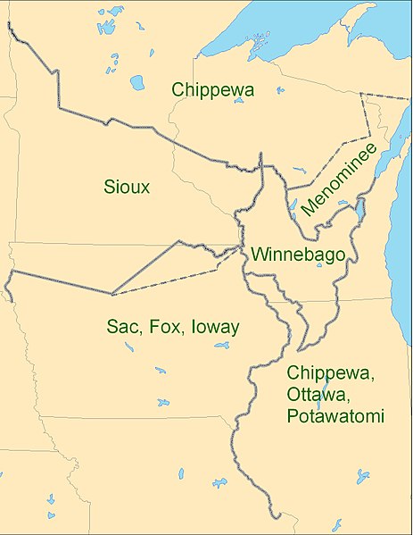
English: Map showing the boundaries between the Sioux (Dakota), Chippewa (Ojibwe), Winnebago (Ho-chunk), Menominee (Menomini), Sauk and Fox (Sac and Fox Nation), Ioway, and the Chippewa-Ottawa-Potawatomi (Council of Three Fires) as per 1825 Treaty of Prairie du Chien |
| Date | |
| Source | Travail personnel |
| Auteur | CJLippert |
Due to uncertainty of Menominee and Ioway boundaries, the parties agreed to adjustments to the 1825-established Prairie du Chien Line once the Menominee and Ioway have determined their boundaries. The adjustment lines shown as dashed boundaries.
Conditions d’utilisation
Moi, en tant que détenteur des droits d’auteur sur cette œuvre, je la publie sous la licence suivante :
Ce fichier est disponible selon les termes de la licence Creative Commons Attribution 3.0 Non Transposé.
- Vous êtes libre :
- de partager – de copier, distribuer et transmettre cette œuvre
- d’adapter – de modifier cette œuvre
- Sous les conditions suivantes :
- paternité – Vous devez donner les informations appropriées concernant l'auteur, fournir un lien vers la licence et indiquer si des modifications ont été faites. Vous pouvez faire cela par tout moyen raisonnable, mais en aucune façon suggérant que l’auteur vous soutient ou approuve l’utilisation que vous en faites.
Historique du fichier
Cliquer sur une date et heure pour voir le fichier tel qu'il était à ce moment-là.
| Date et heure | Vignette | Dimensions | Utilisateur | Commentaire | |
|---|---|---|---|---|---|
| actuel | 3 septembre 2009 à 20:26 | | 1 275 × 1 650 (495 kio) | CJLippert | {{Information |Description={{en|1=Map showing the boundaries between the Sioux (w:Dakota), Chippewa (w:Ojibwe), Winnebago (w:Ho-chunk), Menominee (w:Menomini), Sauk and Fox (w:Sac and Fox Nation), w:Ioway, and the Chippewa-Ottawa-P |
Utilisation du fichier
Les 2 pages suivantes utilisent ce fichier :
Usage global du fichier
Les autres wikis suivants utilisent ce fichier :
- Utilisation sur ca.wikipedia.org
- Utilisation sur en.wikipedia.org
- Utilisation sur en.wikiversity.org
- Utilisation sur es.teknopedia.teknokrat.ac.id
- Utilisation sur hr.wikipedia.org
- Utilisation sur nl.teknopedia.teknokrat.ac.id
- Utilisation sur oc.wikipedia.org
- Utilisation sur sv.wikipedia.org
- Utilisation sur uk.wikipedia.org