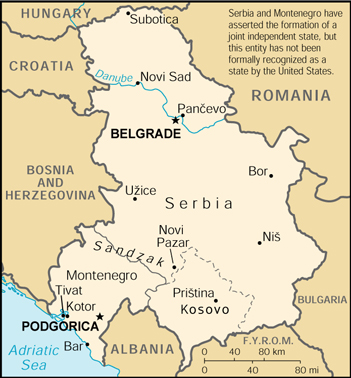
FRYugoMap2k.jpg (351 × 378 pixels, taille du fichier : 116 kio, type MIME : image/jpeg)
Historique du fichier
Cliquer sur une date et heure pour voir le fichier tel qu'il était à ce moment-là.
| Date et heure | Vignette | Dimensions | Utilisateur | Commentaire | |
|---|---|---|---|---|---|
| actuel | 6 février 2007 à 06:18 |  | 351 × 378 (116 kio) | Hoshie | This is a map of The Federal Republic of Yugoslavia (Serbia and Montenegro) [FRY (S&M)] from as the [http://www.umsl.edu/services/govdocs/wofact2000/geos/sr.html 2000 CIA World Factbook] as mirrored by the [http://ww |
Utilisation du fichier
La page suivante utilise ce fichier :
Usage global du fichier
Les autres wikis suivants utilisent ce fichier :
- Utilisation sur en.wikipedia.org
- Utilisation sur es.teknopedia.teknokrat.ac.id
- Utilisation sur fa.teknopedia.teknokrat.ac.id
- Utilisation sur ja.wikipedia.org
- Utilisation sur kk.wikipedia.org
- Utilisation sur mr.wikipedia.org
- Utilisation sur nl.teknopedia.teknokrat.ac.id
- Utilisation sur vi.wikipedia.org
- Utilisation sur zh.teknopedia.teknokrat.ac.id


