


Taille de cet aperçu : 657 × 600 pixels. Autres résolutions : 263 × 240 pixels | 526 × 480 pixels | 841 × 768 pixels | 1 122 × 1 024 pixels | 1 398 × 1 276 pixels.
Fichier d’origine (1 398 × 1 276 pixels, taille du fichier : 312 kio, type MIME : image/png)
Ce fichier et sa description proviennent de Wikimedia Commons.
Description
| Description |
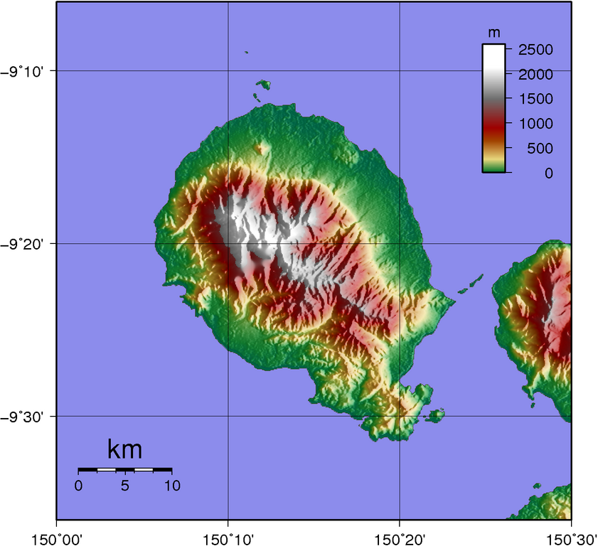
Topographic map of Goodenough Island SRTM data has lots missing data up in the mountains... |
| Date | |
| Source | Created with GMT from publicly available SRTM data |
| Auteur | Sadalmelik |
Conditions d’utilisation
| Moi, propriétaire des droits d’auteur sur cette œuvre, la place dans le domaine public. Ceci s'applique dans le monde entier. Dans certains pays, ceci peut ne pas être possible ; dans ce cas : J’accorde à toute personne le droit d’utiliser cette œuvre dans n’importe quel but, sans aucune condition, sauf celles requises par la loi. |
Historique du fichier
Cliquer sur une date et heure pour voir le fichier tel qu'il était à ce moment-là.
| Date et heure | Vignette | Dimensions | Utilisateur | Commentaire | |
|---|---|---|---|---|---|
| actuel | 2 juin 2007 à 12:31 | | 1 398 × 1 276 (312 kio) | Sadalmelik | |
| 1 juin 2007 à 21:56 |  | 1 398 × 1 276 (304 kio) | Sadalmelik | {{Information |Description=Topographic map of Goodenough Island SRTM data has lots missing data up in the mountains... |Source=Created with GMT from publicly available SRTM data |Date=1st June 2007 |Author= User:Sadalmelik }} [[Category:Maps of Papu |
Utilisation du fichier
Les 2 pages suivantes utilisent ce fichier :
Usage global du fichier
Les autres wikis suivants utilisent ce fichier :
- Utilisation sur als.wikipedia.org
- Utilisation sur arz.wikipedia.org
- Utilisation sur ceb.wikipedia.org
- Utilisation sur de.teknopedia.teknokrat.ac.id
- Utilisation sur el.wikipedia.org
- Utilisation sur en.wikipedia.org
- Utilisation sur es.teknopedia.teknokrat.ac.id
- Utilisation sur fa.teknopedia.teknokrat.ac.id
- Utilisation sur gl.wikipedia.org
- Utilisation sur he.wikipedia.org
- Utilisation sur it.teknopedia.teknokrat.ac.id
- Utilisation sur ka.wikipedia.org
- Utilisation sur nl.teknopedia.teknokrat.ac.id
- Utilisation sur pnb.wikipedia.org
- Utilisation sur pt.teknopedia.teknokrat.ac.id
- Utilisation sur ru.teknopedia.teknokrat.ac.id
- Utilisation sur sw.wikipedia.org
- Utilisation sur vi.wikipedia.org
- Utilisation sur www.wikidata.org
- Utilisation sur zh.teknopedia.teknokrat.ac.id