


Taille de cet aperçu PNG pour ce fichier SVG : 800 × 438 pixels. Autres résolutions : 320 × 175 pixels | 640 × 351 pixels | 1 024 × 561 pixels | 1 280 × 701 pixels | 2 560 × 1 403 pixels | 1 460 × 800 pixels.
Fichier d’origine (Fichier SVG, nominalement de 1 460 × 800 pixels, taille : 735 kio)
Ce fichier et sa description proviennent de Wikimedia Commons.
.svg?uselang=fr)
Description
| Description |
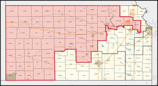
English: The congressional district, highlighted in red, overlayed with other congressional districts and county boundaries, as well as major roads, water areas, urban areas, parks/forests, military installations, and American Indian areas (including reservations) in Kansas, with neighbouring states coloured in gray. Shapefiles from the United States Census Bureau, the Federal Highway Administration, the Kansas Department of Health and Environment ([1] [2]), the United States Forest Service, and the National Park Service, converted with Mapshaper (Mercator projection). |
| Date | |
| Source | Travail personnel |
| Auteur | Twotwofourtysix |
Conditions d’utilisation
Moi, en tant que détenteur des droits d’auteur sur cette œuvre, je la publie sous la licence suivante :
Ce fichier est sous la licence Creative Commons Attribution – Partage dans les Mêmes Conditions 4.0 International.
- Vous êtes libre :
- de partager – de copier, distribuer et transmettre cette œuvre
- d’adapter – de modifier cette œuvre
- Sous les conditions suivantes :
- paternité – Vous devez donner les informations appropriées concernant l'auteur, fournir un lien vers la licence et indiquer si des modifications ont été faites. Vous pouvez faire cela par tout moyen raisonnable, mais en aucune façon suggérant que l’auteur vous soutient ou approuve l’utilisation que vous en faites.
- partage à l’identique – Si vous modifiez, transformez ou vous basez sur cet élément, vous devez distribuer votre contribution sous une license identique ou compatible à celle de l’original.
Historique du fichier
Cliquer sur une date et heure pour voir le fichier tel qu'il était à ce moment-là.
| Date et heure | Vignette | Dimensions | Utilisateur | Commentaire | |
|---|---|---|---|---|---|
| actuel | 17 mai 2023 à 01:11 | | 1 460 × 800 (735 kio) | Twotwofourtysix | Uploaded own work with UploadWizard |
Utilisation du fichier
La page suivante utilise ce fichier :
Usage global du fichier
Les autres wikis suivants utilisent ce fichier :
- Utilisation sur en.wikipedia.org
- Utilisation sur ko.wikipedia.org
- Utilisation sur zh.teknopedia.teknokrat.ac.id
.svg)