


Fichier d’origine (770 × 950 pixels, taille du fichier : 108 kio, type MIME : image/jpeg)
Ce fichier et sa description proviennent de Wikimedia Commons.
Description
| Description |
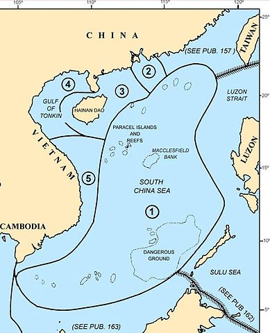
Map of the w:South China Sea region showing the areas covered by NGA Pub. 161, Sailing Directions (Enroute) South China Sea and the Gulf of Thailand, Fifteenth Edition, 2014 |
| Date | |
| Source |
Page IV of http://msi.nga.mil/MSISiteContent/StaticFiles/NAV_PUBS/SD/Pub161/Pub161bk.pdf |
| Auteur |
National Geospatial-Intelligence Agency (NGA), |
| Autorisation (Réutilisation de ce fichier) |
© COPYRIGHT 2014 BY THE UNITED STATES GOVERNMENT NO COPYRIGHT CLAIMED UNDER TITLE 17 U.S.C. |
| Autres versions |
 File:Pub161-pg1.jpg File:Pub161-pg1.jpg |
Conditions d’utilisation
Ce média est dans le domaine public des États-Unis d’Amérique car son auteur est l’administration américaine comme précisé dans le code fédéral au Titre 17, Chapitre 1, Section 105. Pour en savoir plus : droit d’auteur.
Attention : Ceci ne concerne que le travail du Gouvernement Fédéral et pas celui des États, ou d’une autre subdivision géographique ou politique du pays.
|
 | |
| Ce fichier a été identifié comme étant exempt de restrictions connues liées au droit d’auteur, y compris tous les droits connexes et voisins. | ||
Historique du fichier
Cliquer sur une date et heure pour voir le fichier tel qu'il était à ce moment-là.
| Date et heure | Vignette | Dimensions | Utilisateur | Commentaire | |
|---|---|---|---|---|---|
| actuel | 30 novembre 2014 à 05:44 | | 770 × 950 (108 kio) | Pdfpdf | trim off top border (2 pixels) |
| 30 novembre 2014 à 05:26 |  | 770 × 952 (109 kio) | Pdfpdf | {{Information |Description= Map of the w:South China Sea region showing the areas covered by NGA Pub. 161, ''Sailing Directions (Enroute) South China Sea and the Gulf of Thailand'', Fifteenth Edition, 2014 |Source=Page IV of http://msi.nga.mil/MSIS... |
Utilisation du fichier
Les 2 pages suivantes utilisent ce fichier :
Usage global du fichier
Les autres wikis suivants utilisent ce fichier :
- Utilisation sur en.wikipedia.org
- Utilisation sur ur.wikipedia.org
- Utilisation sur vi.wikipedia.org
- Utilisation sur www.wikidata.org
- Utilisation sur zh.teknopedia.teknokrat.ac.id