Taille de cet aperçu : 610 × 600 pixels. Autres résolutions : 244 × 240 pixels | 488 × 480 pixels | 781 × 768 pixels | 1 042 × 1 024 pixels | 2 083 × 2 048 pixels | 2 718 × 2 672 pixels.
Fichier d’origine (2 718 × 2 672 pixels, taille du fichier : 372 kio, type MIME : image/png)
Historique du fichier
Cliquer sur une date et heure pour voir le fichier tel qu'il était à ce moment-là.
| Date et heure | Vignette | Dimensions | Utilisateur | Commentaire | |
|---|---|---|---|---|---|
| actuel | 10 novembre 2008 à 11:57 |  | 2 718 × 2 672 (372 kio) | Luca Bergamasco | {{Information |Description= |Source= |Date= |Author= |Permission= |other_versions= }} |
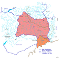
| 10 novembre 2008 à 11:00 |  | 2 718 × 2 672 (369 kio) | Luca Bergamasco | {{Information |Description={{it|1=Carta schematica della sezione numero 2 delle Alpi secondo la SOIUSA (Alpi Marittime e Prealpi di Nizza) con evidenziati: le sottosezioni, l'idrografia |
Utilisation du fichier
Les 2 pages suivantes utilisent ce fichier :
Usage global du fichier
Les autres wikis suivants utilisent ce fichier :
- Utilisation sur br.wikipedia.org
- Utilisation sur ca.wikipedia.org
- Utilisation sur es.teknopedia.teknokrat.ac.id
- Utilisation sur fa.teknopedia.teknokrat.ac.id
- Utilisation sur hr.wikipedia.org
- Utilisation sur it.teknopedia.teknokrat.ac.id
- Utilisation sur pt.teknopedia.teknokrat.ac.id
- Utilisation sur www.wikidata.org


