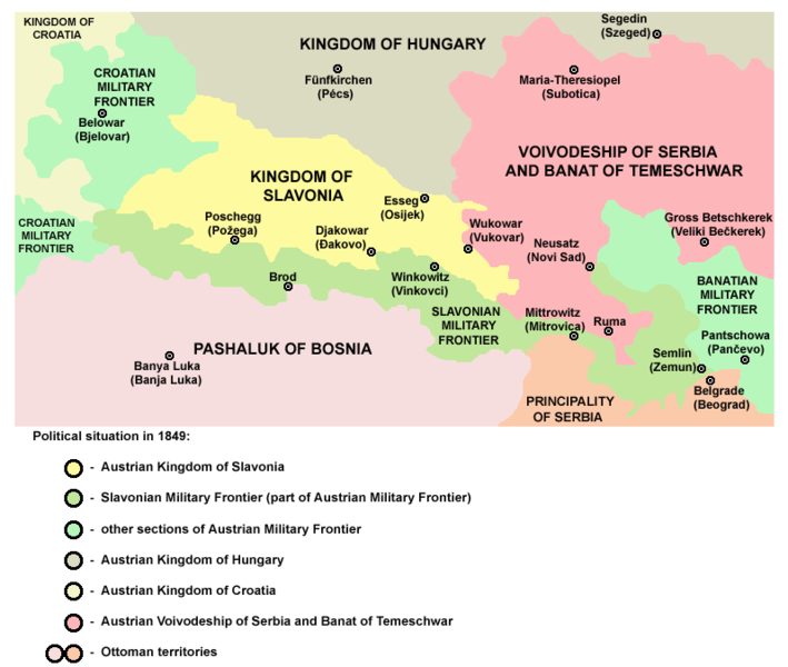
Taille de cet aperçu : 709 × 600 pixels. Autres résolutions : 284 × 240 pixels | 568 × 480 pixels | 797 × 674 pixels.
Fichier d’origine (797 × 674 pixels, taille du fichier : 81 kio, type MIME : image/png)
Historique du fichier
Cliquer sur une date et heure pour voir le fichier tel qu'il était à ce moment-là.
| Date et heure | Vignette | Dimensions | Utilisateur | Commentaire | |
|---|---|---|---|---|---|
| actuel | 12 avril 2011 à 10:22 |  | 797 × 674 (81 kio) | WikiEditor2004 | improved version |
| 20 mai 2007 à 20:26 |  | 726 × 510 (21 kio) | Minestrone | Enhanced version | |
| 28 décembre 2006 à 16:41 |  | 726 × 510 (13 kio) | Electionworld | {{ew|en|PANONIAN}} historic map (self made) {{PD-self}} Category:Maps of the history of Croatia Category:Maps of the history of Vojvodina |
Utilisation du fichier
La page suivante utilise ce fichier :
Usage global du fichier
Les autres wikis suivants utilisent ce fichier :
- Utilisation sur an.wikipedia.org
- Utilisation sur be.wikipedia.org
- Utilisation sur cs.wikipedia.org
- Utilisation sur de.teknopedia.teknokrat.ac.id
- Utilisation sur en.wikipedia.org
- Utilisation sur et.wikipedia.org
- Utilisation sur eu.wikipedia.org
- Utilisation sur fa.teknopedia.teknokrat.ac.id
- Utilisation sur gl.wikipedia.org
- Utilisation sur he.wikipedia.org
- Utilisation sur it.teknopedia.teknokrat.ac.id
- Utilisation sur ja.wikipedia.org
- Utilisation sur mk.wikipedia.org
- Utilisation sur nl.teknopedia.teknokrat.ac.id
- Utilisation sur pt.teknopedia.teknokrat.ac.id
- Utilisation sur ro.wikipedia.org
- Utilisation sur sr.wikipedia.org
- Utilisation sur uk.wikipedia.org


