


Fichier d’origine (Fichier SVG, nominalement de 1 535 × 1 550 pixels, taille : 824 kio)
Ce fichier et sa description proviennent de Wikimedia Commons.
Description
| Description |
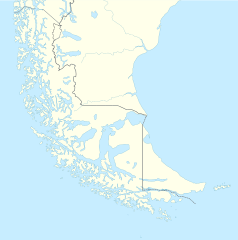
Deutsch: Positionskarte von Feuerland und Umgebung
Quadratische Plattkarte, N-S-Streckung 160 %. Geographische Begrenzung der Karte:
English: Location map of Tierra del Fuego and surroundings
Equirectangular projection, N/S stretching 160 %. Geographic limits of the map:
Español: Ubicación de Tierra del Fuego y alrededores
Proyección equirectangular, N/S 160% de estiramiento. Límites geográficos del mapa:
|
|
| Date | ||
| Source |
Travail personnel, using
|
|
| Auteur | NordNordWest | |
| Autorisation (Réutilisation de ce fichier) |
Ce fichier est disponible selon les termes de la licence Creative Commons Attribution – Partage dans les Mêmes Conditions 3.0 Allemagne.
 Ce fichier est disponible selon les termes de la licence Creative Commons Attribution – Partage dans les Mêmes Conditions 3.0 Allemagne.
|
|
| Autres versions |
Œuvres dérivées de ce fichier : |

.svg)

|
Cette carte a été créée ou améliorée dans le Kartenwerkstatt (Atelier cartographique allemand). Vous pouvez également y proposer des cartes à améliorer.
|
Historique du fichier
Cliquer sur une date et heure pour voir le fichier tel qu'il était à ce moment-là.
| Date et heure | Vignette | Dimensions | Utilisateur | Commentaire | |
|---|---|---|---|---|---|
| actuel | 5 mars 2024 à 18:20 | | 1 535 × 1 550 (824 kio) | Janitoalevic | More specific Beagle Channel |
| 29 décembre 2022 à 03:23 |  | 1 535 × 1 550 (588 kio) | Janitoalevic | Improved borders | |
| 3 mai 2020 à 21:41 |  | 1 535 × 1 550 (566 kio) | Janitoalevic | Improved Isla de los Estados | |
| 3 mai 2020 à 20:47 |  | 1 535 × 1 550 (558 kio) | Janitoalevic | Improved | |
| 30 août 2017 à 01:23 |  | 1 535 × 1 550 (441 kio) | Janitoalevic | Fixed size | |
| 29 août 2017 à 13:23 |  | 1 535 × 1 550 (510 kio) | NordNordWest | Reverted to version as of 20:59, 15 March 2016 (UTC); change of size is catastrophic to some templates | |
| 29 août 2017 à 00:18 |  | 1 638 × 1 653 (442 kio) | Janitoalevic | More precise borders and lakes | |
| 15 mars 2016 à 22:59 |  | 1 535 × 1 550 (510 kio) | Janitoalevic | Fixed limits following Google Earth/maps limits | |
| 3 mars 2016 à 00:12 |  | 1 535 × 1 550 (510 kio) | Janitoalevic | Updated | |
| 11 septembre 2015 à 22:34 |  | 1 535 × 1 550 (508 kio) | Janitoalevic | Added Southern Patagonian Ice Field (Campo de hielo Patagónico Sur) undefined limits part, since 1998 For more information read: https://teknopedia.ac.id/wiki/Southern_Patagonian_Ice_Field#Borderline Now with full resolution. |
Utilisation du fichier
Les 61 pages suivantes utilisent ce fichier :
- Aguilera (volcan)
- Archipel Madre de Dios
- Archipel de Hanovre
- Archipel de la Reine Adélaïde
- Aéroport international Presidente Carlos Ibáñez del Campo
- Canal Smyth
- Cap Froward
- Cerro Bertrand
- Cerro Daudet
- Cerro Murallón
- Cerro Paine Grande
- Cerro Piergiorgio
- Cerro Pietrobelli
- Cerro Standhardt
- Cerro Stokes
- Cerro Torre
- Champ de glace Sud de Patagonie
- Détroit de Magellan
- Détroit de Nelson (Chili)
- Glacier Amalia
- Glacier O'Higgins
- Glacier Olguín
- Glacier del Francés
- Glacier los Perros
- Lac Argentino
- Lac Dickson
- Lac Nordenskjöld
- Lac Paine
- Lautaro (volcan)
- Monte Burney
- Parc national Torres del Paine
- Phare Evangelistas
- Puerto del Hambre
- Reclus (Chili)
- Réserve nationale Alacalufes
- Vallée del Francés
- Viedma (volcan)
- Voie du compresseur
- Île Caracciolo
- Île Chatham (Chili)
- Île Cochrane
- Île Contreras
- Île Guarello
- Île Hanovre
- Île Jorge Montt
- Île Juan Guillermos
- Île Madre de Dios
- Île Maldonado (Natales)
- Île Manuel Rodríguez
- Île Pacheco
- Île Pedro Montt
- Île Ramírez
- Île Riesco
- Île Tarlton
- Île Vidal Gormaz
- Île Wellington
- Île du Duc-d'York (Chili)
- Îles Lobos
- Îles Rennell
- Îlots Fairway
- Modèle:Géolocalisation/Patagonie australe
Usage global du fichier
Les autres wikis suivants utilisent ce fichier :
- Utilisation sur als.wikipedia.org
- Utilisation sur ar.teknopedia.teknokrat.ac.id
- Utilisation sur az.wikipedia.org
- Utilisation sur ba.wikipedia.org
- Utilisation sur bn.wikipedia.org
- Utilisation sur ceb.wikipedia.org
- Utilisation sur cs.wikipedia.org
- Utilisation sur da.wikipedia.org
- Utilisation sur de.teknopedia.teknokrat.ac.id
- Utilisation sur el.wikipedia.org
- Utilisation sur en.wikipedia.org
- Tierra del Fuego
- Ushuaia – Malvinas Argentinas International Airport
- Isla Grande de Tierra del Fuego
- Puerto Williams
- Río Grande, Tierra del Fuego
- Diego Ramírez Islands
- Riesco Island
- Hoste Island
- Viedma (volcano)
- Cerro Torre
- Fitz Roy
- Viedma Lake
- Gallegos River
- Mount Darwin (Andes)
- Puerto Toro
- Dawson Island
- Ildefonso Islands
- Hermite Islands
- Southern Patagonian Ice Field
- Navarino Island
- Cordillera Darwin
- Cordillera Sarmiento
- Londonderry Island
- Hornos Island
- Grey Lake
- Desolación Island
- Clarence Island, Chile
- Gordon Island
- Juan Guillermos Island
Voir davantage sur l’utilisation globale de ce fichier.